How Maricopa Association of Governments improved its travel demand models with AirSage

About Maricopa Association of Governments

The Maricopa Association of Governments (MAG) is a Council of Governments (COG) that serves as the regional planning agency for the metropolitan Phoenix area. Its member agencies include 27 cities and towns, 3 native nations, Maricopa County, portions of Pinal County, and the Arizona Department of Transportation. MAG develops and maintains a number of transportation modeling tools required for regional planning processes. The Travel Demand Modeling Program at MAG is involved in the development, maintenance and support for application of these travel forecasting models.
Map of Maricopa Association of Governments Zone

Challenge

Historically, MAG has relied on a number of different data sources for estimation, calibration, and validation for its travel demand models. Sources include household travel surveys, intercept surveys, acquired account data, purchased speed data, census data, travel reduction program data, and ridership data from the regional transit provider. However, these data sources may not account for some segments of the population, such as the visitor population. Visitors to the region are hard to survey and if surveyed, provide limited information. Knowing the increasing accuracy of location-based services (LBS) data, MAG Travel Demand Modeling Program staff investigated the use of LBS data to fill these gaps and to supplement existing data sources used by the forecasting models.

Decision

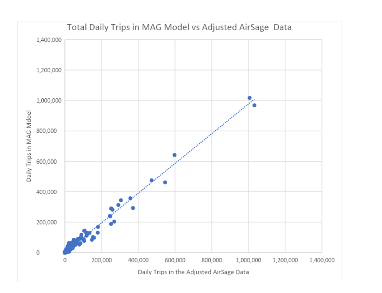
AirSage provided samples of data for MAG to test prior to purchase. After thorough testing, the MAG Travel Demand Modeling Program concluded the data would be quite valuable for their modeling (see graph below). MAG modeling staff noted that in addition to being highly accurate, location data could also be acquired quickly (within weeks), and the price point compared to surveys was quite reasonable. Given the above, they decided to move forward.
graph showing MAG data compared to AirSage data
Graph above shows how district-to-district flows (total daily person-trip) from MAG model compare to district-to-district flows from adjusted AirSage data. The district-to-district flow comparisons for the model trips vs adjusted AirSage trips were concluded to be statistically similar (R^2=98%). 


Results

With AirSage, MAG has been able to successfully validate trip origins and trip destinations at the district level in their travel forecasting models and fill in the gaps left by surveys. Petya Maneva, Transportation Engineer IV at MAG, explains, "Location-based services data enhances our survey data and gives us more fidelity in our travel demand models."

Higher data quality

MAG receives greater sample sizes and broader spatiotemporal coverage with AirSage compared to surveys.

Time savings

AirSage location data can be acquired within weeks which is especially useful for a project with fast-turnaround.

More insights

AirSage provides more insights about visitors, whose behavior had been very challenging to measure due to limited survey responses.
"Location data like AirSage data is a very useful supplement to survey data and other sources we use. 
- Petya Maneva, Maricopa Association of Governments

Contact us to learn more

© 2023 AirSage Inc. All right reserved.
cross