LBS Data is Not Dead (Part 2): A Study of Actual Traffic Events Using AirSage Location-Based Services Data
Introduction:
In our previous article LBS Data is Not Dead: The Changing Landscape of Location Based Services Data for Transportation Planning, we acknowledged the concerns in the transportation planning industry regarding the value of location-based services (LBS) data. Data providers exited the market, causing a general decrease in data availability. However, despite these changes, LBS data remains a highly valuable resource for various use cases, with AirSage continuing to provide high-quality, accurate and reliable data.
Visualizations:
To illustrate the high level of accuracy and quality of AirSage's LBS data, let's examine visualizations of AirSage’s LBS data at three locations included in a recent evaluation:
1.) I-95 in Philadelphia, Pennsylvania: The following images present LBS datapoints (i.e., mobile device pings) in the vicinity of a catastrophic event wherein an entire segment of I-95’s both northbound and southbound was destroyed in a crash involving a tractor trailer. The left image presents typical conditions and the right image presents conditions during the full roadway closure.
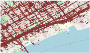
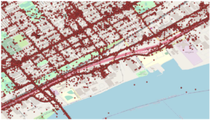
As expected, the area of the roadway closures on I-95 during the roadway/bridge closure was clear of all LBS sightings.
2.) I-15 in Las Vegas, Nevada: The following images present LBS datapoints in the vicinity of a crash involving a pedestrian on I-15. The left image presents typical conditions and the right image presents conditions during the closure of all southbound travel lanes.
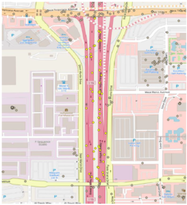
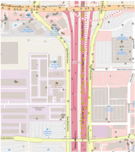
During the closure of all southbound travel lanes on I-15, the southbound lanes were clear of all LBS sightings, while the northbound travel lanes still provided LBS sightings, aligning with expectations.
3.) I-90 in Schaumburg, Illinois: The following images present LBS datapoints in the vicinity of a crash involving multiple vehicles on I-90, northwest of Chicago. The left image presents typical conditions and the right image presents conditions during the closure of eastbound travel lanes, with shoulder use observed.

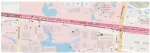
The eastbound travel lanes were heavily congested but not completely closed due to the crash event (shoulder use was observed for a number of vehicles traversing through the scene). LBS sightings along the eastbound lanes were concentrated west of the crash site, as anticipated.
Why is AirSage Data Accurate?
Before agreeing to leverage location data from any data provider, AirSage conducts a comprehensive vetting process. In addition to this qualitative review, AirSage also ensures that each potential data provider complies with strict privacy regulations and meets the highest standards of quality. Although competing organizations have access to location data from similar data providers, AirSage distinguishes itself through its data sourcing, cleansing, and processing approach, in addition to its technical expertise. The AirSage team cleanses the data to the highest extent possible, removing instances of data that are unsuitable for transportation planning purposes.
Conclusion:
Based on the evaluations conducted for the three event locations and the resulting visuals that present AirSage’s LBS data, it is evident that AirSage's LBS data accurately captures movement activities. The examples reinforce the high quality and level of accuracy provided by AirSage's LBS data. Transportation professionals can confidently rely on the insights derived from AirSage’s LBS data to make better-informed decisions.
AirSage's LBS data enables transportation professionals to enhance their understanding of human movement, identify home and work locations, infer trip purposes, and gain insights into various modes of transportation used for a trip. As the landscape of location-based services data continues to evolve, AirSage remains committed to delivering reliable, high-quality, and accurate mobility data for the transportation planning industry.
To learn more about AirSage LBS data, visit AirSage's website.
About the Author:
Jonathan Silverberg, CTO & Co-President of AirSage has over 22 years of experience in senior technology management. He is the former CEO at Decell, a global leader of real-time traffic information specializing in leveraging mobile signaling data as well as GPS data for transportation applications. He is also the inventor of several granted patents in the fields of mobile communication and traffic information.